Tuesday, January 17, 2017

Manatee to Rainbow Springs

 IF you don’t like the weather in Florida today – wait a day or so and it will change - 2 days rain, then 2 days cold, then 2 days warm and repeat!  While it never got warm enough for these old folks to jump into the 70-degree spring water, we did have some sunshine and a few days to see manatee out in the Suwannee River again.


The next couple days were the cold and damp ones.  A haze had settled in like a feather duster on a spindle bed over Shell Mound Park at the mouth of the river where it meets the Gulf of Mexico. Folks out on the elevated fishing pier were all dressed for the cold dampness as they tried casting their shrimp loaded hooks out in what water was left as the tide slithered out of the bay. Their small children behaved like any bored children and repeatedly threw rocks and stones into the muck below.  Farther out on Cedar Key the foggy haze still lay over everything and you could not see from one end of the waterfront eateries and shops to the other where the slimy boat launch sat empty and ignored.

Inland towards Ocala, Dunnellon and our past favorite Rainbow River State Park we pressed, with hopes of some sunny weather and my long awaited visit with my sister and her hubby.  Sunny - we had - but the COLD soon followed.  High 20’s and very low 30’s at night and barely up to 50 during the day seemed to be the new norm.  My winter coat even came out of hiding from under the bed!   In years past we’ve spent our Christmas’ with D&S but since we came down a different route this year, I had to wait for my hugs and Dick’s fun dose of orneriness. 
 

Straight down Rt 200, on the banks of the Withlacoochee River, sits the rustic old building which still houses the Stumpknockers Restaurant.  I had my first taste of alligator there a bunch of years ago!   My catfish dinner was good but H’s choice of stuffed flounder did not make him as happy.   After our dinner we stepped carefully thru the cypress roots down to the river’s edge. The reflection of the Rt 200 Bridge cast its double image on the dark calm water.  The many Cypress trees showed fresh looking high water marks from all the previous heavy rains.


Hiding among the many tree roots was a large black gator that thought he could make a meal of me!  He attempted to clamp his mammoth gapping jaws on my foot and ankle but I yelled and swiftly grabbed my leg and pulled my very important limb back to safety!  Dick bravely grabbed the reptile’s stiff upper jaw and wrestled the creature back to its previous stoic pose!  A very close call!  And Sharon?  She just shook her head and dared to laugh.

In the “Good Ole’ Days” of camping at Rainbow Springs State Park, the camp was divided into the upper (RV) sites and the lower (tent, trailer and pickup truck camper) sites. The park has been remodeled so the lower area is now all day use and the upper areas have been upgraded and new bathhouses built.  They can erase the fun camping spots below but not the sweet memories of good friends and canoeing and amazing snorkeling on the river!


Our stay at the state park would not be complete without a visit to the clear aqua water of the headsprings.   The many walkways and paths that surround the springs are lined with Azalea bushes and Camellia trees.  At Christmas time when we usually are here, the park is decorated with many sparkling lights that light up all the walkways – this time it was the many Azaleas and Camellias that now shed their delicate glow along the way in shades of red, white and soft pink blooms!

But enough!   Trimble Park just south of Mount Dora, is calling and the weather is warming again.   Let’s see if we can park in one of the nine waterfront sites for the next two weeks.

Thursday, January 5, 2017

Happy New Year

Move? We’ve moved and then moved again!  From one seaside state park we headed east along the beautiful “Emerald Coast of Florida” to another seaside state park in Panama City Beach.  We had stayed in St Andrews State Park on our very first winter of retirement – SPFB!  Our site way back then was spacious and backed right up to the bay.  Not so lucky this time!  H had managed to reserve the very last site that was open for only one night.  It was narrow – down right malnourished - just like the rest of the sites in that section.  After much jockeying and frustration the big tan condo was backed in and secured for our short stay.  The “roads” thru the camping areas were not much more than 2-tracks in the sand with palms and pine trees left growing way too close to maneuver around easily.  We witnessed more than one rig have a difficult time getting into his tight spot.  We chose to not even try for another site the next day.
St Andrews beach

We used the afternoon to re-explore the park.  We walked the off white sand cliffs on the beach.  Erosion was still happening and we heard they were dredging the bay to fill in the beach-AGAIN!  It’s Christmas break so the park was full of families and teens!  We took time to walk the fishing piers and watch the seabirds beg for the fish scraps at the cleaning shed.  There was even a tri-colored heron on the roof that sat like Snoopy on his doghouse with his head cocked over the edge to stare down!  

We were packed and out early the next morning – still following the route along the shoreline.  The beautiful beaches had now changed to rocky shallow bays and the road followed obediently along and around each one.
St George Island Lighthouse
H chose to follow a “Scenic Florida Highway” sign and we ended up on a long strand of bridge out over the bay to St George Island.  At the end of the 3-mile causeway was the normal collection of tourist shops, a row of 3-story, parallel townhouses stacked side by side like pastel dominos-ready to fall if nudged.  A tall, stately 1843 lighthouse and keepers house stood guard over a neatly groomed park with plenty of informative signs to read. The lighthouse had been destroyed by storms in 2005 and has been rebuilt using the salvaged bricks. The boardwalk nearby led over the scruffy dunes to the YELLOW sand beyond.  It was cold and windy so there were not too many folks frolicking in the water today!

That afternoon we parked in a small “fishing camp” campground – the Newport County Park on the St Marks River.  Right across RT 98 was the road to the St Marks Lighthouse and Wildlife Refuge.   Last spring the area was damaged by Hurricane Hermaine, and the shoreline at the lighthouse still showed some residual damage.
 
Wakulla lodge
 We chose to spend several nights and so took a day to see if Wakulla Springs State Park was still doing well.  It is!  The agent at the gate had to charge us an entry fee but was nice enough to inform us that we could use that receipt towards any cost of a meal (breakfast!) at the restaurant in the lodge.  The lodge was and is still a step back into a grander time! Their Christmas tree was still up and the decorations fulfilled the feeling of the era.  A toasty fire was crackling in the huge fireplace. The spring is still a first magnitude spring and the resident manatees still follow the tour boats around and rise to the surface as if on cue.
Wakulla Springs

It was New Year’s Eve and there was to be a big celebration, complete with fireworks that evening in Tallahassee at a park near the capitol building. Since we were not going to be in Tallahassee after dark, we wanted to at least see the park where all the fireworks were to be set off.  It was not on our GPS so we wandered from the east side of town to the west - right thru the Florida State University campus!  Right past the Seminole Stadium - the guys that beat the Michigan Wolverines in the Orange Bowl by ONE lousy point.  We never did find the park. Defeated also – H and I headed back to our snug little winter home.

We’ve gone from the “Emerald Coast”, thru the “Forgotten Coast” where the tenor of the area changed from sparkling water and tourists to tidal flats and fishing villages.  Around and down the “Big Bend” of the Gulf side of Florida we lucked out and got a “walk-in” site in Manatee State Park near Chiefland.   Manatee Springs had been closed a year ago for updating electrical and
Manatee Springs
sewer hookups.  Not much else has been done. From December to April, the actual run is usually off limits (because in the cool weather, manatees come up in the run from the river).  Not so this year.  The kayak and canoe rental is going strong!   During the day, there is still a pod of 4 or 5 manatees out in the area where the spring empties into the Suwannee River and can be seen from the boardwalk, the fishing dock – or from your kayak or canoe!   The spring is still flowing 72-degree clear water.   On one trip to the spring to watch the swimmers in the water, we saw more than just kids bobbing around.  We were
Mermaid in Manatee Springs
amazed to see a Mermaid with long shimmering blue green fins!  H and I even got to talk with her!   Her name is Serena and has wanted to be a mermaid since she was a small girl!    Cool, huh
!

Thursday, December 29, 2016

Christmas on the Beach

On Christmas Day, while walking on the snow-white sandy beach in 80 degree weather - we came upon these two snowmen who were lounging in the warm sunshine.  Did they really think they could lie out in the Florida sun and not melt?  Did they also mistake the sand for snow?   Didn’t they ever listen to “Frosty the Snowman”?   What was to become of them?


On one of our exploration ventures we found a road that took us out on a guardian peninsula that protects the harbor and all the moored vessels in the bay.  Mansions line the narrow roadway but at the end of it is a long narrow sandy public beach dotted with scrub and clumps of sea oats and a heron that thought he was invisible as long as he stood perfectly still.  The opposite side of the beach is the gulf and a tall white dune of sand separates the two.  From this vantage point you could see all the elbow-to-elbow vessels backed into narrow berths with their sterns up against the long wooden boardwalk.  On one end of the boardwalk was the multi layer shopping area with the normal tourist tee shirt shops, a mammoth resort, and a handful of restaurants and bars.  A lighthouse, a pirate ship, zip line towers and palm trees strung with lights complete the collection.


We returned to the Harbor Walk Village side of the bay as the sun was setting and the lights on the docks were starting to slowly illuminate the pathways. We came across this beautifully preserved and painted tree and had to read the large historic sign posted near it. It had once been a 40-foot Magnolia tree that was over 100 yrs old.  In honor of Captain Leonard Destin, it has been preserved and carved with all kinds of sea life.  Double click and see how many creatures you can find.  See the swimmer with his long black flippers?  The eagle?  The other side also has a large sea turtle and sailfish!


Reminiscent of the Christmas Parade, the local pirate ship and tourist ferryboat were still decorated for the holidays and their multicolored lights danced on the now dark waters below as they quietly rested at their mooring.

Pleasure boats were returning to harbor and seabirds where heading for their roosts as the sun settled into the clouds on the far horizon on the distant side of the silhouetted bridge that connects the Oskaloosa barrier island to Destin.


The Christmas Season is in full glory at the Bass Pro Shop and the adjoining modern mall that surrounds it like a village!   Topiary reindeer line the streets, music fills the air and the highlight of it all is the tall, wonderfully decorated Christmas tree in the center square!  A colorful child sized train chugged from one end of the mall area to the other, carrying its small sized passengers as it traveled along.


OH, by the way – H has instructed me to assure you all that he has rescued the melting snowmen and they are being iced down so they will survive to spend another Christmas Holiday with us!!!  COOL!!


We’re hoping your Christmas was blessed and your expectations were fulfilled.

Stay with us – we’re moving again! 

Thursday, December 22, 2016

Gulf Shoires to Destin

This may not be one of “THE” Blue Angels but this island also has plenty of these blue Herons!!!  We were walking on the beach and the fishing pier on the bay side of the island and this big fella kept moving out in front of us.  He finally took off just as I snapped this photo!!  He’s flying – and he is blue!


One clear day we chose to try and get closer to the Blue Angels since I was not able to catch them as they roared over our
campground.  We left the island and headed for the Pensacola Naval Station – just in case they would be flying while we were in their neighborhood!  No luck but as in our last trip to this area we did find the Pensacola lighthouse.  It was all decorated in Christmas wreaths and garlands!  The lighthouse sits high on a hill right across the
View of  Fort Pickens from across the bay
bay from “our” island and Fort Pickens.  Zoom in on the picture and you can see the fort and the white sand on the island’s tip.  As the crow flies it’s about 3 miles but by GPS it’s more like 25 miles by road!!    The lighthouse shows up much better while standing on the warm sand on our island while the waves from passing boats splash up on shore.
Pensacola Lighthouse from Ft Pickens

After we first arrived on the island and once all the rain had stopped and the flooding had dissipated, we could see a large black hulk lying on the sparkling white beach at waters edge.  The powerful salvage vehicles had finally been called and the huge skeleton of the shipwrecked vessel had been turned over and drug up to the
road’s edge – causing the newest traffic bottleneck by gawkers wanting a better look  - or maybe a picture?!  


We strolled thru the Civil War part of the Fort once again (SPFB!) and the limestone secretions were still there and maybe the stalactites were getting a bit longer as they clung to the damp roof of the ancient arches.   We found more WWII batteries outside of the thick brick walls of the original fort and climbed up their steep black steps to view the gray clouds that were covering up the sky that day.

Our other new friends, Richard and Rachael moved out on Saturday to get ahead of the next predicted thunderstorm and we finished packing up to head out ourselves on Sunday.  I would love to hear from both of my newly gained Alabama girlfriends again!

As we drove east along the entire length of the Gulf Seashore Island, it had a light covering of misty fog.  Heavy charcoal clouds hung out over the gulf and showed streaks of rain alternating with bands of sun.  We exited the island at Navarre Beach and must have been the only ones to have noticed the rainbow’s colorful bands against the cloudy sky as the light rain drops fell and the sun burst thru over the gulf!


Henderson Beach State Park is east of Fort Walton Beach, another barrier island bridge and touristy Destin.  When we stayed here 10 years ago on our way to Texas, the road out front was a quiet 2-lane road with just wind blown dunes and a solitary Wal-Mart across the
road.  Now there are towering condos and resorts lining each side of the fast moving 4-lane highway.  The harbor has a boardwalk that stretches the length of shops and restaurants - from the bridge’s span to the distant end of the scrunched together rows of yachts and commercial vessels.  When we were here before it was the winter right after Katrina and I remember several boats moored at the docks were survivors of that horrid storm.   There had been a lighted boat parade that we watched from the boardwalk with all the rest of the folks!  This year we’ve missed it by one weekend.  Drat!   However – like everything else – it has probably grown way too big and way too crowded and maybe not nearly as much fun as before.  That or we’re just getting OLD!!??   Nah, not us!

The campsites and facilities are just as great as we remembered – groomed, private sites and the bathrooms are tiled and heated. 
There is a boardwalk that crosses the rugged dunes like the Great Wall of China but I did not remember it being Sooooo long!!  The cold and wet weather has abated again. The warm sunshine has returned.  Now it’s back to beach walking on the snow white crystal sand with the aqua blue waves lapping at the shore, bike riding and breakfast outside.


On the island off Pensacola we listened to the jets and airplanes that flew from the Naval Station.  In Destin we are just south of Elgin Air Force Base and we get to watch a different crop of aircraft fly over!  More jets, lots of helicopters and we even saw a VTOL!  H said it was a Vertical TakeOff & Landing plane - I called it a cross between a helicopter and a jet!

 Christmas is almost here!  May yours be Merry and Joyous and Bright!

Tuesday, December 13, 2016

Gulf Islands National Seashore


Gulf Islands National Seashore is a series of barrier islands that protect the coastal areas of Mississippi, Alabama and Northwest Florida.  In Texas they also have the Padre Islands National Seashore.  On our first winter’s trip, we blogged about camping on South Padre and also at the northern end of that chain of islands.  See “Previous Florida Blogs” for our last visit here, too!
 
The four inches of rain from last Sunday finally quit coming down but the solitary 2-lane road that leads from the park entrance gate, past the check-in building, and on to the campgrounds was flooded and took 5 days to dry up!  Our campground loop was fairly high and the water drained pretty quickly but the other, larger campground loop did not fare so well!  It’s a good thing that all of the electrical boxes are mounted 4 feet off the ground on tall wooden posts.


We’ve already gone thru the main part of the fort before but on each visit we find more to inspect and learn about.  This time we’ve checked on the World War I Cooper’s Battery that held the disappearing canons.  These canons popped up, disappeared and reappeared like jack in the box!  According to the sign nearby, this battery held 2 6inch rifles mounted on disappearing carriages.  When the guns were fired, the recoil automatically lowered them behind the concrete wall, which protected the crews while they reloaded the guns.  Counterweights then returned them to the firing position.


Flooded park roads did not hold us back from venturing out to explore Pensacola and surrounding areas.  On Pearl Harbor Day we headed back to Mobile and the Battleship Memorial Park where we toured the battleship, USS Alabama and the submarine, USS Drum.   Alabama is 680 ft long and 108 ft wide!  She carried 9 16-inch guns in 3 main turrets, 20 5-inch guns, 48 40mm guns and 52 20mm guns!  Her crew numbered up to 2500!  We followed the self-tour signs thru the lower two levels past the galleys, bunks and even the bathroom area which was what amounted to a long plank w/toilet seats attached
and one long trough underneath. (Ewww!)  While below we also saw the engine room and the room where the HUGE big guns on the top of the ship got aimed.  We saw rows and rows of missiles and the area where the smaller 5” bullets were stored and then placed in a conveyer tube and sent up to the guns above.  On the above decks you could see what her sailors and marines would see – except now it includes the city skyline and the collection of restored military airplanes in the surrounding park area below.


H chose to return to our base via a different route – a ferry boat from Dauphin Island - a barrier island south of Mobile to Fort Morgan Island – another long narrow barrier island on the east side of the bay.   On both sides of Mobile Bay are 2 more restored forts and each faces the Gulf of Mexico and had once protected the mouth of the Bay.   Out in the open water were imposing oilrigs on tall metal legs.   We passed fairly close to one set of two that were joined by a small bridge.  As we rumbled past and approached the commercial channel, our captain had to throttle back and wait for a long slow moving freighter to pass by and head out to the Gulf of Mexico.  Those of us who were up on the observation area of the ferry got an extra bonus when we watched 2 dolphins leap up and out of the water as they chased along!


We’ve met some neat folks – Wanda and Ed are from the Mobile Bay area and filled us in on some of the local lore. We shared a walk on the beach and a gorgeous Gulf Sunset with them.  Another local neighbor is an armadillo who wanders along and thru the scrub bushes behind our “home”! We’ve seen eagles and osprey and have listened to all kinds of little birds that flit from one tree to another!  And then there are the jets that take off and land all day long from the Pensacola Naval Air Station - right on the other side of Pensacola Bay.  This morning we heard an exceptionally loud roar above us and looked up just in time to see the Blue Angels fly over in formation. Before we leave – I MUST get a picture.  IF I am successful – that picture will be the first thing you see on our next blog!
Not Snow

Our daily routine has settled in to riding the bikes, walking the beach, watching for eagles (or angels!) and occasionally driving the 4 miles back up the road past the gatehouse, thru drifting snow and piled up drifts along the road!   Snow?!  Sorry – I meant SNOW WHITE SAND!!  Snow white SAND!  

Thursday, December 8, 2016

Heading South

Thanksgiving is over – the sweet potatoes and pies are all devoured.  All our doctor appointments are completed.  The Ohio State-Michigan football game has been played and the boys in the winged maize and blue helmets let the Buckeyes win again. It’s now December!  The trailer is packed and ready to go!
 
Crossing into Kentucky
Our southern direction has changed from heading southeast to southwest since we’re heading for the Gulf of Mexico first on this trip.  Our journey down and across Indiana on state roads (not expressways) was great and we watched the landscape gradually change from flatland farming with their corduroy textured, harvested fields to gently rolling hills covered with pastures or wooded acres.   Along with all the rest of the Friday afternoon traffic, we crossed the wide Ohio River on one of the multiple spans of the I 65 bridges – so much for the peaceful ride!  Down below, there were tugboats and long narrow coal barges chugging their way downstream on their own watery expressway.
The Natchez Trace

From Louisville thru Nashville we stayed in the middle lane and let the traffic flow around us!  Thru Nashville and finally onto the Natchez Trace – we could breathe again! We slowed down and began to enjoy the ride once more!  No semi trucks and not much traffic at all – just a deer darting across the blacktop and leaping into the brushy undergrowth and a humongous flock of dark black turkeys that thought they owned the road and wanted to play chicken with the big blue truck!  Then the rains came!  And they kept coming for 3 more days!
The Tenn-Tom River

We parked that night in David Crockett State Park, just outside of Lawrenceburg Tennessee.  The town is full of history from the infamous Trail of Tears to the famous folks who called the town home, including Fred Thompson the actor and congressman.  The MOST famous tho, is Davy Crockett himself!   His history and lure permeates every inch of the town and the state park that is his namesake!  The park boasts 2 modern campgrounds, cabins, a restaurant, archery, tennis and Frisbee golf.   There is a museum/grist mill and a covered bridge that straddle the Shoal Creek where Davy once lived, worked and earned the title of Colonel before heading to the Alamo.

Tennessee and Mississippi on the Trace and then off for the last time as we followed more state roads thru BIG sounding small towns of Louisville and Philadelphia to another state park – Clarkco State Park. Another set up and take down in the rain!  This park was easy to get to from Meridian but the park roads were extremely narrow and tall pine trees stood guard at and behind every narrow site and at each bend of road.

It was a comparatively short jaunt across the cotton fields of Alabama to the gulf coast city of Mobile and US Route 10.  Route 10 seemed like one continuous bridge from Mobile, over creeks, swamps and low areas to the Florida border!   As we crossed the bridges from Pensacola to the barrier island of Santa Rosa the skies opened up even further and the watery deluge came in waves of blinding precipitation.  The windshield wipers struggled to keep up!  We later found out that the amount of rain that day set a new record of 4 inches!   Once in the Fort Pickens Campground in the Gulf Shores National Seashore Park, the downpour let up long enough for us to park on site A14, which will be our home for the next week and a half.  That respite was brief however and the downpour returned and continued thru the night.  Our camping loop fared pretty well but the other one did not and most everything except the parking pads and roadway was underwater the entire next day!   

The rain has now stopped and the “exploring” can begin!

Friday, November 11, 2016

Belle Isle Park Detroit Mi.

The calendar may say that summer is over and it is now mid November but the wonderful, warm, sunny weather is still with us and we are taking advantage of every bit of it!  Our flowerbeds are all covered up for the winter and the last of the veggies are out of the garden. New tulip bulbs with their promise of bright spring
Maumee River
colors have been buried deep in the dark earth.  One last trip up the Maumee River in the boat with our dear friends, Bud and Carol and last week a day trip up I 75 to downtown Detroit and out onto the historic and beautiful Belle Isle Island in the middle of the Detroit River.

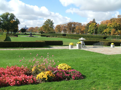
Belle Isle Park is a Detroit gem and has become Michigan’s 102nd state park.  This 985 acre island is home to a variety of attractions including a nature zoo, the James Scott Memorial Fountain, the Nancy Brown Peace Carillon, the Livingstone Memorial Lighthouse, lots of playgrounds, walking trails, sports fields and 2 marinas!

Our first stop on the island was the oldest aquarium in the United States built in 1907.  This ceramic tiled domed building houses more than 1,000 fish and an extensive collection of Belle Isle memorabilia.

Next we toured the Anna Scripps Whitcomb Conservatory - the oldest continually running conservatory.  This expansive collection included a formal garden, several seasonal floral beds, a lily pond tucked behind an elaborate wrought iron fence, and an awesome view of the tall towers that make up the Renaissance Center in downtown Detroit.  Inside the high glassed in structure were rooms of tropical plants and vine drenched tall palm trees that reached the ceiling above.  One room was filled with desert plants and blooming cactus of all sorts.  Another held ferns and flowers.


Detroit skyline
We tried our best to drive on every road as it wound around the perimeter of the fall colored island with stops on the Detroit side to view the skyline and the bridge that crosses to Windsor Ontario.  On the other side of the island we caught the blues and greens in the reflections of the water across from the carillon. Our final stop on the island was at the Dossin Great Lakes Museum.  After viewing a movie documenting Detroit’s maritime history, we browsed the halls to see all the displays of boats and the history that came 
with them.  We even walked in the captain’s footsteps on the bridge of a Great Lakes freighter in the William Clay Ford Pilot House!  Out of those windows you could easily see the Canadian shoreline!  Outside were even more displays!   “Miss Pepsi” – the first hydroplane boat to top 100 mph had her own glassed in display!  There were cannons and anchors also - including the original anchor from the Edmund Fitzgerald!
Windsor Ont. Ca. across the River 
All of this activity made us hungry so we crossed from Detroit to Dearborn and went to Buddy’s Pizza for the BEST pizza we’ve ever found!  If you go – try the “ Henry Ford”!   Ground beef, SMOKED bacon, red onion and Blue Cheese - all on a multi grain thin crust!!
Now we must find time to plan for Thanksgiving and then pack for Florida!  The weather will surely be colder by then!