Wednesday, October 3, 2018

Go West 2018 Part 1

Of course, the night before we’re scheduled to head out on an adventure – neither one of us sleeps well.  Up early and the little “burro” was loaded.  Lights and timers checked, water turned off, house and garage locked – let’s go!  It’s been a bunch of years since we’ve been out west but the route was the same – US24 to Ft Wayne and beyond.  When my sons were small we used to travel the same route each summer when they got to spend time on my sister & brother in law’s farm in western Indiana.  US24 went straight thru Ft Wayne and the boys delighted in watching the traffic lights change from red to green in front of us ALL the way thru town. Then the expressways came on the scene and we circled the town via Rt469 around the south end of town and then a shortcut back to 24.  Now Rt 24 has been switched to around the north end and it threw me for a loop but we regained our bearings and on we went!   US 70 took us from Indiana to Central Illinois with a night in Effingham.

With the sunrise at our backs we continued on and slid into the backed up “go to work” traffic in East St Louis!  We were
catapulted over a bridge and had to fight our way thru one-way streets to find a parking spot near the National Park that sits on the edge of the river. The Gateway Arch is the same but now has an awesome museum and new entrance nestled below the towering shiny metal arch.  It’s still dizzying to stand at the base and attempt to look up to the top!  We waited our turn and then obediently climbed into the “dryer tub” drum and held our breath as it slowly churned its way to the top,
along with the captive folks in the 7 other freshly painted “canisters”.  At 630 feet high, the narrow, curved viewing area was noisy with the excited chatter of visitors jockeying to get a good view of the Mississippi River on the east side or the old courthouse and downtown on the west side.  In the early morning sunlight, the arch cast a long dark shadow over the Park’s campus and buildings below!  On our way back to the “dryer tub” to return to terra firma, I was overheard making a comment about how dark and steep the steps down to the transfer tub was, so we were given #3 to wait for instead of one farther down!  Down and out into the humid and hot downtown weather we quickly found our way back to the patiently waiting Jeep and headed west across Missouri and entered into Kansas.


When we traveled on the big red motorcycle (back in our much younger days) we always said:  It took us 4 days to cross Kansas - one afternoon! This time we stopped in Topeka for the night! 
Abilene was next on our list of places to stop to explore.  The town was founded in 1857 and was named after a Bible verse: Luke 3:1, which described Abilene - a region in Galilee as the City of the Plains.  Wild Bill Hickok with the Chisholm Trail came next!  Now the town’s claim to fame is “the town that raised a president” as this is where Dwight D Eisenhower grew up.  We found his childhood home and his Presidential Library but again, we were too early so we walked the grounds and then continued our westward route.

In Oakley Kansas we found the Buffalo Bill Cultural Center and it’s twice life size bronze sculpture of Buffalo Bill Cody on his
horse, Chisholm - pursuing a buffalo!  25 miles south of Oakley we bravely followed the seemingly endless, excessively dusty, gravel road to find Monument Rocks, which were out in the middle of NO WHERE!  Also called the Chalk Pyramids, these 50 ft majestic chalk spires are the eroded remains from sedimentary deposits from melting glaciers and seaway – 80 million years ago!


Eastern Kansas is agricultural. Western Kansas is – WESTERN – dry and tan – as is eastern Colorado.  Limon was as far as we dared travel that day since Denver was the next Mega Town that we would need to endure.   Our bodies were still on Ohio time so we were up at 5am Colorado time – 7am Ohio time.  On the road just as the sun was climbing out of its slumber in the eastern sky – we ended up in “go to work” traffic crawling thru the Mile High City!   On the far side of Denver, the terrain changed from flat and
brownish gray to colorful rock formations and mesas standing high above the winding expressway below.  Imagine taking a beach bucket and standing a brick inside it.  Then fill it with damp sand and turn the bucket over – letting the drying sand gently fall down the sides of the brick.  As we passed one unique formation, yet another would appear on the horizon.  The winding, ever climbing Rt70 followed the valleys and narrow passes thru the Rockies and let us stop at 12000 ft and the ski village of Vail.  Even in 80 plus degree weather the upscale resort area was busy with tourists strolling in and out of small boutiques and up and down the brick walkways.  Our strolling was done and it was time to move on!  One more stop was at a scenic
turnout, complete with a serene little reflection lake and bright yellow Aspens glowing on the mountainside behind it.   UTAH was our destination - Green River the town.

Saturday, August 4, 2018

2018 up north week 2

Petoskey area is still stunningly beautiful!  Rolling hills and artistic touristy towns dot the cliffs and shorelines of the sparkling blue Lake Michigan!  We “did” them all – Charlevoix with it’s long
protecting breakwall with the red lighthouse prominently guarding the entrance to the harbor; Petoskey with it’s awesome views and historic old homes and downtown buildings.  And don’t forget Harbor Springs with its ever-changing roster of grand yachts and antique boats moored almost side by side!   We were told the sleek silver creature belongs
to the Vicari family who own the Andiamo Italian Restaurants up in the Detroit area!  And the antique boat is a restored 1934 craft that is now used for tours for the restaurant there in the harbor.  Our Up North Trip would not be complete without a visit to Soo Ste Marie in the Upper Peninsula where we spent time with our former neighbors!  That was the rainy day and the passing freighters were enveloped in a shroud of mist and fog as they churned on towards the mammoth locks ahead.


We now have fish in the freezer!  What an exciting morning – H
hooked a good-sized bass but it straightened out the hook!  Then the scrappy fish spit it back at him when it finally reached the side of the boat.  Next was a pike – it tore a hole in H’s antique fish net.  It was followed by a beautifully designed orange and blue Sunfish that was bigger than most.  I followed with a just slightly smaller Bluegill!  We finished up with a few assorted rock bass!  The rest of the excitement for the day was when B&C finally showed up in their new small motorhome!  They were going to be with us for 4 nights and we were going to make the most of each day!

First it was up the Lake Michigan coast, along Sturgeon Bay to
Mackinaw City to play tourist!   Bud needed more stickers of the great lakes and Carol and I just wanted to shop.  Lunch at Scalawags is always a must and the perfectly done fish and chips hit the hungry spots in our tummies!  Down the road to Cheboygan - the Sunrise Side of the Mitten of Michigan and out to the harbor to refresh our memories and to see if we could still see Bois Blanc Island out in the distance.  A reminiscing stop at the eternal JUNK store confirmed our guess that the mess had piled up higher than on our last visit a year ago!   Our 2nd day was back to Petoskey to check out the enormous hardware store in downtown and to stroll out on the breakwall with the rest of the tourists who were in town that day.  The Polish Kitchen finished up that trip!  This time H and I split a Pork Cutlet Sandwich and a
plate of 6 Pierogis – perfect!  Carol had to have help but her plate of the Polish Sampler was cleaned up by the time we left.  Our last day was the best – we slid the Tracker back into the clear water of Pickerel Lake and we headed to Crooked Lake to show B&C the beautifully crafted two masted sailboat we had seen on our previous rides.  Thru the locks and on we cruised along the winding river called CROOKED!  Out on
Burt Lake the water was still calm and we headed north to Maple Bay so H could show them the State Forest Launch and Campground where we had put the boat in the week before.  On our way back, Carol even spotted an eagle, soaring majestically overhead!


We waved B&C Goodbye and wished them safe travels and after sitting for a while, H couldn’t sit any longer so off we went!  It was a windy day and he wanted to see if any tiny sailors were bouncing around the harbor in Harbor Springs. SPMB!!!   Instead, we found the 198-foot, MEGA YACHT – “ROCK IT” owned by
the man known as JIMMY JOHN!  This $85 MILLION yacht had been in harbor for almost a week and as we walked out on the pier to join the other gawkers – she was unhooked from her moorings and she powerfully backed out into the bay.  Her mammoth size made the 5 other mega yachts still in harbor look like run abouts!

Now it’s our turn to move on – on down the state to North Higgins Lake State Park - just south of Grayling.  Michigan State Parks are notorious for being very popular and thus – crowded.  While the sites in this park were ample, most were filled to the brim with
assorted RV’s AND pop up shelters AND tents AND boats on trailers.  Of course there was also the assortment of bikes ranging from full size down to tiny ones, still with training wheels!  PLUS -cars AND trucks either parked very near or actually ON the narrow road’s edge – which can make it difficult to maneuver a big tan train back into the assigned site - - IN THE RAIN.  As we backed in, there was just a mild drizzle but it quickly turned to a deluge as soon as we got the cover on the boat!

Our last days out were a mix of rain and clouds so the deep blue of the 100 ft depths of this big lake were not on display very often.  On our boat rides we did cross over the 90 and 100 ft areas and when the sun was peeking thru – the waters were the deep magnificent turquoise that we remembered, and the shallows were the still the opaque light blue shimmering reflections on the sandy bottom – but that was a rare sighting on this visit!

We added one more fish to the freezer and then packed to head home.  Time to tend to the gardens and get the grass mowed.  Tomatoes should be coming on and who knows how big the zucchini are!! 

Wednesday, July 11, 2018

Summer 2018

Perry's Peace Monument
Harry intends on getting lots of use out of the spiffy new electric fold up bikes that replaced the little fold up bikes he sold down in Florida.   We folded them and packed them into the cavernous back area of the minivan and headed east to the shores of Lake Erie and the passenger ferry that hauls people and cars from the mainland out to the popular tourist island of South Bass Island where the Perry’s Victory and International Peace Monument anchors the center of the 3 mile long island.

The 325 ft tall monument honors the battle of 1812 in Lake Erie.  It has just been refurbished and is now back open to visitors on the
View from the TOP!
bustling weekend tourist town of Put In Bay!   We left our bikes at the base of the towering granite column and climbed the allowed portion and then safely finished the trip to the observation deck at the top via the air-conditioned elevator!   The views in each direction were stunning in the calm noonday sun!  Since it was still early in the season the harbor was almost void of pleasure boats that would soon be moored off of each other in their quest to reach the land and local eateries and bars.  Put In Bay is known for it’s partying crowds on the weekend!  The streets will be full of bikes and rental golf carts!  Now, from high atop the monument – the quiet scene below looked almost serene.   

Up and around the rolling hills and back roads, our trusty steeds carried us along – sometimes under our own power and sometimes not!   A stop to check out the island’s state park campground and launch area gave us a cool spot to soak in the rocky cliffs that
View from South Bass State Park
encircle this historic island.  Our last stop was to visit the South Bass Island Lighthouse that was built in 1893 and is on the southern tip of the island.  It is the only lighthouse owned by a university!  Yes – the Ohio State University.   Our return ferry ride was shared with a group of zealous and tired school kids but our new bikes
1893 South Bass Lighthouse
passed them up as we cranked the throttle and sped quickly up the steep drive and headed for the van once the ferry was back to the mainland!

The gardens are well and the grass is mowed.   The boat has been in several lakes and several fish are now in the freezer.  H’s doctor appointments are behind him and our next trip is in front!  

As our usual summer trip planning goes, the direction dial is ALWAYS set to due north!  The “train” has 4 new, AMERICAN made, 10 ply tires (instead of 8 ply), new brakes and new equalizer bars on both axles.  My beloved 12 yr old Chrysler Town & Country minivan has been replaced with a 2019 Jeep Cherokee Latitude PLUS!  This cute little granite colored vehicle will do most everything except the dishes!  It has a huge front to back sunroof (for me!) and the 4x4 tow package (obviously for him!).  The back-up camera and braking system is taking a bit to get used to.  Ask H how much fun it was to try and back the Jeep up to hook up the boat trailer!  It wouldn’t let him!  And how fun it was trying to back that trailer into the garage - - with the parking assist turned on! This frustrated little car didn’t want H to back into the trailer - that was attached to its own back bumper!!  Thankfully H found the button on the dash that turns that off!   So now we are ready to go north!

SPMB - See Previous Michigan Blogs!  Our trip to the North Country is normally up Rt 52, breakfast in Chelsea or Owosso and a jaunt over to Rt 127.  Breakfast was in Chelsea but this time we headed straight north out of Owosso –staying on Rt 52.  H is pulling the “train” and me ‘n the little Jeep, pulling the Tracker fishing boat - are following behind.  Our own little parade!   About 4 miles north of town, smoke begins to billow out from the right
rear corner of the train.  Grabbing the walkie-talkie, I yell into it to pull over NOW – there’s smoke!  Scenes of a similar incident with the Rockwood Trailer, on top of a mountain in North Carolina, filled my mind!  The blowout on the new tire was caught in time to avoid further damage to the heavy trailer that it was supporting!   I’ll now give a plug to the emergency road service of Safeco Insurance Company since they quickly found a serviceman who came to our rescue.  He got us back on the road soon after the spare tire was secured in place of the damaged tire - that had a
chunk of metal gouged into its tread.  Our trip was further hindered by road closures and bad back road detours but our first nights rest was in the lovely St Louis Church of God Campground, just east of the tiny town by the same name!  Up and out early Sunday morning, we cruised up Rt 127 and then melted into traffic on always busy I 75! 


Camp Petosega is now our home for the next 2 weeks!  Site #62 is mostly shaded and only a short walk thru the woods to the always clean bathhouse!  The weekenders have now gone to their respective homes and jobs and we are left with the peaceful beautiful scenery and the music of the many birds that sing us (ME) awake each morning!  The boat has been in 3 lakes so far – Pickerel, Crooked and Burt Lakes. No fish have been injured in any of these ventures as of yet.  Darn.  Soon tho!

Friday, June 1, 2018

Chicago Spring 2018

We left the gorges and waterfalls of the Illinois River Valley and headed back towards the northeast and the other river that connects the Mississippi and Illinois Rivers to Lake Michigan - the Chicago River.  Traffic on I 80 was bad and got worse the closer we got to Joliet and eventually South Chicago and the Indiana state line.  Off the expressway to save on H’s nerves – we ended up in backed up traffic in Gary Indiana.  Oh well, Rt 12 led us to the Indiana Dunes National Seashore and the state park right next door!   In the past we’ve always camped at the National Park Campground but there is no electricity in that park and the weather was to be pretty cool at night. (Here it is: See Previous Summer Blogs!)
The state park still has buildings from the CCC era but the campgrounds and other park areas have been nicely updated.  The parking pads are wide and long with lots of new small trees are planted between the sites. 

The Southshore Rail line still runs on schedule to downtown Chicago and the train stop is right down the entrance road to the park with plenty of free parking.  Even tho the price for seniors to
ride has gone up – from $3.75 to $4.50, the fast electric train still speeds along and still glides to a smooth stop at each posted station with the final stop in the dark caverns of the train station at Millennium Park.  Once back up in the sunlight, our eyes adjusted to the bright light in the “canyon” formed by the towering
skyscrapers on Michigan Avenue.  We dodged other pedestrians and tried not to stumble as we (ME) craned our necks skyward to gaze at the tall spires above us.  Our mission for the day was to find and explore the Riverwalk along the Chicago River that had not been there on our last visit!  As we walked, we could see the massive monuments that have guarded the Michigan Ave Bridge for years.   Each roadway that parallel Michigan Ave has its very own dark colored, double decked, counterweighted drawbridge that keeps traffic moving across to the other side.  Down on the river, the taxi and tour boats were zigging and zagging their watery ways up and down the river.  Loudspeakers blared explanations of what the
gawking tourists were to be looking at.   Gazing down from the main street level, the cement valley that followed the river was lined with trees, restaurants, boat docks and ample sitting areas for downtown workers and tourist alike to sit and relax and watch the world go by.  Some folks were strolling along, enjoying the sunshine, some were jogging and some were walking their well-behaved dogs.  


Climbing up out of the valley we found ourselves in an amazing park created especially for children!  The sprawling Maggie Daley Park had wide curving walkways dividing different areas built for fun – climbing walls, skating areas and age appropriate playgrounds.  A shiny stainless steel bridge swirled up and around like an escaping snake before crossing over the busy road beneath it. The downward path on the other side took us to the backside of the huge green swath of grass that lay before the super modern
metal amphitheater.  We were told that all kinds of entertainment are put on there and folks bring their blankets or lawn chair to enjoy summer concerts and programs.  A must see in Millennium Park is the famous stainless steel Chicago Cloud Gate Sculpture!    Affectionately named “The Bean” because of its shape, it is 33x66x42ft and the archway underneath is 12 ft tall.

We wandered farther south of the “Bean” looking for ice cream but instead saw groups of families curiously watching a 50 ft tall tower with an animated face taking up the entire side of it.  The face was moving and we both scanned the crowd looking for the child who was making the faces being mirrored on the wall.  Turning around, we saw an identical tower with a man’s face on it.  Water was spitting out of the man’s mouth!   There was no such
man in front of that tower!  These glass-bricked, dual LED lit water towers were using digital photos of local residents to mesmerize all of us!

We were both getting tired and ice cream was on our minds!  Across busy Michigan Ave was the Shake Shack located in the bottom corner of a wonderfully restored old hotel with high, gold like ceilings, marble floor tiles and wide marble stair casings!   YES - the shakes were delicious!   

We came! We saw!  We were now VERY tired and decided it was time to find the train station and find our seats for the ride back to Indiana and the state park.   We slept well that night and in the morning we slid in the slides and pulled up stakes and followed Rt 12 into southern Michigan and headed home!  We’ll travel again - - soon, no doubt!

Tuesday, May 29, 2018

North Central Illinois

Spring has sprung in southeast Michigan.  H is restless.  He spun the direction dial and West won.  We pulled out and followed Rt 20 around the tall stately monument in the center of Angola Indiana.  Just past Lagrange, the Shipshewanna Flea Market was open and parking was still free till after Memorial Day so we got our walking exercise in and even did a little shopping.  Our first night’s destination was Potato Creek State Park, 15 miles south of South Bend.  It hasn’t changed any since the last time we stopped on another adventure, 10 years ago! 
 
Illinois River
We stayed just one night in Potato Creek because they were full for the upcoming weekend.  H thought wisely and called Starved Rock State Park in Ottawa Illinois to make sure they had a place for us to park for the duration of our trip.  Nope - they were booked solid, and it wasn’t even the holiday!   Illini State Park, west of Joliet and about 20 miles east of Starved Rock, still had a few “walk in” sites available – so we headed there, via the Lincoln Highway (Rt 30) and then Interstate 80.

Illini State Park is named after an Indian tribe who once called the area home.  It sits on the Illinois River across a high bridge from Marseilles (Mar – sales).  It’s French and they too lived in the area for a while!  Our first glimpse of the long winding river, broken up by a plethora of locks and dams, was of a laden barge being pushed up the river past a pleasant little park with a statue of its namesake proudly keeping watch.   Illini has 2 camping loops – one is right next to the river, across from one set of locks and has clean, but older facilities.  The other loop has no facilities other than a not yet smelly pit toilet building and electricity.  The beautiful wooded surroundings totally made up for it and it was not difficult to jump in the truck and drive to the other loop for a good, hot (almost scalding!) shower.

In Florida, two years ago we met John and Anne who were from NE Illinois.  John came to visit us at the campground!  He and H played with the drones and rode our NEW electric fold-up bikes! (Remember – H sold our old fold-up bikes down in Florida!)  I was saddened because sweet Anne was not feeling well and could not make the trip to enjoy the conversation and the great lunch out at the Marseilles Family Diner.  Get Well, dear Friend!
On top of Starved Rock

Starved Rock State Park and the surrounding area is not the flat boring expanse of farmland that make up most of the state.  The Illinois River Valley was carved by melting glaciers surging thru sandstone rock.  During early spring, after the winter thaw and frequent rains, Starved Rock brags about her 18 canyons and waterfalls with vertical walls of moss-covered stone that create settings of geologic beauty.   The parks namesake is a real rock!  Pontiac, chief of the Ottawa tribe was slain by the Illiniwek tribe and the battles began.  A band of the Illiniwek sought refuge on top of the 125-foot sandstone butte.  The Ottawa tribe surrounded the bluff until the hapless tribe at the top died of starvation.  On our first visit to the park we did climb the steps AND the hill – and THEN up the 65 wooden steps to the top of the famed rock to gaze out over the river and dam below and the “Lovers Leap” on the neighboring sandstone cliff.   Walking along the top edge, looking out over the available 3 sides of awesome viewing was well worth the huffing and puffing to get to that point!
water fall at St Louis Canyon

Our day for hiking to a waterfall was on a Saturday.  All the state parks were full of groups of families out for a nice day.  The overflow parking lots were definitely all overflowing!!  We took our second choice of falls to go find because its location was at the outer edge of the park with its own parking area.  However, the parking area was blocked off so we ended up parking near the highway and walking down the pockmarked deteriorating blacktop just to get to the sign directing us to the St Louis Canyon.  The .3- mile hike from there was also not handicap accessible – a narrow sand path on the edge of deep ruts of babbling water.  Then it was up steps and then down more steps. The sand path continued downward, with roots creeping across them as they attempted to hold the sand from sliding into the
stream of water below.  As we rounded a curve and over another small bridge, the view opened up to the huge half circle bowl and the steady stream of water that splashed to the pool at the bottom from what seemed like the highway heights above.  By the time we returned to the parked truck, we were both hurting and out of breath!
path to the canyon


Of course, the nearby towns were explored – Marseilles, Ottawa, Utica and Streator.  Streator’s claim to fame is their “Walldogs” artists and their Festival of Murals each June/July.  While driving their main
downtown Streator Ill.
street area we saw what we thought was a restored old block of town.  As we approached we realized we were looking at a 3 dimensional mural that took up the entire side of a building!  Ottawa has its history with Abraham Lincoln’s first debate in 1858 and the nearby Buffalo Rock State Park.  This park has a collection of outdoor earthen sculptures, inspired by Native American burial grounds.  The images were wasted as the grass had not yet been mowed and the best viewing needed to be from above.  Buffalo Rock is also home to 2 American Bison who were oblivious to me wanting to get their photo thru the 2 fences of their enclosure.


I’ve got more of our adventure to show and tell you about, but I’ve run out of time and space!   I’ll continue soon and tell you about Chicago!

Tuesday, April 10, 2018

Alabama & Heading Home

The national weather forecast was showing a huge blob of magenta and red, surrounded by yellow and green, starting to cross the USA map.  H was getting concerned.  The storm was due in 3 days and we were heading right into its path.  We hit the road early and headed for the Florida/Alabama border and straight towards
Montgomery.  Traveling north on Rt 331, we saw another ominous color in the sky ahead of us – DARK charcoal and it wasn’t in the form of a threatening heavy rain cloud.  As we approached the city limits of the small country town of Brantley, the thick smoke ahead of us billowed and rolled up and across the countryside.  Flashing emergency lights pulsed at ground level as more and more firemen and other first responders appeared on the scene.  As we slowly crept by the Brantley Recycle Center we were thankful that there were no ambulances at that scene.  We heard on the radio later that there had been no injuries and the fire had finally been gotten under control.

North of Montgomery and just outside of Wetumpka, Alabama, in the crook of the Coosa and the Tallapoosa Rivers, are the remains of Ft Toulouse and Ft Jackson, along with the adjoining sad,
Fort Toulouse
neglected campground.  History abounds in this area!  First it was the Native Americans who called this land “home”.  Then came the French who built Ft Toulouse in the early 1700’s.  After that it was the British who let the fort deteriorate.  Then came General Andrew Jackson and his American forces who built Ft Jackson near the same site as the original French Fort.  Today, Ft Toulouse is a split timber replica of the original and the earthen
Fort Jackson
walls of Ft Jackson are just the beginning of the reconstruction of the 1814 fort.

The storm threat is getting closer as we push farther north.  We’re heading to the northeast corner of the state and the Desoto State Park in Ft Payne.  In the 1930’s, the park, nestled atop beautiful Lookout Mountain, was developed in the rustic tradition of the Civilian Conservation Corp.  This 3,500-acre park has chalets, cabins, a lodge, a restaurant, a well stocked general store and an improved campground with full hookups and cable!

While the state park is within the boundaries of the Little River Canyon National Park Preserve, the fast flowing waterfalls and the nearby visitor center are ten miles from the campground.  The
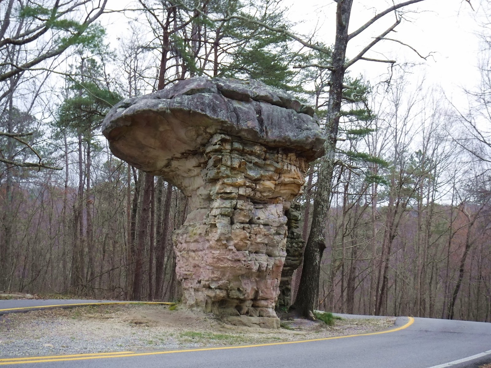
eleven-mile, winding scenic road follows the edge of the canyon, which at times is 500 ft from the edge of the cliffs to the sandstone canyon below.  The 2-lane road has plenty of scenic turnouts and we made the best of all of them to view the white water rushing below us or the dogwood and honeysuckle that clung to the edges of the viewing areas or even the homes perched on the opposite side of this vast gorge.  We had to stop and marvel at the mammoth Mushroom Rock that was
standing guard in the center of the ribbon of road before us. How many millions of years has it been standing there?   In a few weeks when the trees turn green and the wildflowers bloom, this area will be even more of a sight to behold!


The storm is really close!  As we pull out early the next morning, the sky is gray but we’re hoping to still be ahead of the impending threat.  Neither one of us like traveling on Interstates when we’re
Mushroon Rock
pulling the “train”, but we’ve got miles to go this day so we slid into traffic on I 24 and pointed the truck towards Nashville.  The rain caught up to us and we drove thru the drizzling precipitation, up around that town, heading to Kentucky.  Now it’s I 65, and the downpour continued all the way to Louisville.  Rough roads and ponderous truck traffic beat at us but we made it across the mighty Ohio River and sighed with relief.  It was raining but we made it to Indiana at last.

It was still raining when we finally arrived at the Versailles State Park, one mile east of the town of the same name and on the over flowed banks of the Laughery River.  All of the rivers and fields in southern Indiana and northern Kentucky were underwater and this campground was no exception.  Luckily the parking pads were of blacktop and above the soggy, water soaked grass.

It was STILL raining the next morning as we headed for the last push to home.  Crossing from Indiana, finally to Ohio we gladly stopped in Defiance to have lunch with our dear, retired NCR friends, George and June.   The deluge was really coming down as the constant rush of monster semi trucks chased and roared past us throwing even more water at our windshield as we continued our last leg home.

We have survived!   The trailer is unloaded but not yet moved to its real parking spot in the back yard – way too soggy to go there yet!    The waterbed is finally warm and so is the house!  The winter’s collection of downed branches and twigs have been picked up and burned!  My spring urge to plant is diffused with the planting of my tomato seeds in tiny greenhouses!   H’s new electric fold-up bikes have arrived and have been put together and tested!  Now he’s making plans for the next trip!

Wednesday, April 4, 2018

North Florida

So, we all know that Florida has 1350 miles of coastline and that all the different sections of the coast have names - from the First Coast (St Augustine), to the Space Coast (Titusville), to the Treasure Coast ((Melbourne), to the Sun Coast (Tampa), to the Nature Coast (Crystal River), the Forgotten Coast (Keaton Beach to
Pier at Mexico Beach
Apalachicola) and lastly the Emerald Coast (Mexico Beach to Destin).  From Keaton Beach around the bend to Apalachicola (I love to say that word!) and on to Mexico Beach, tourism has not been actively promoted – until recently.  Each time we visit M.B. the rows of small condo buildings and the collection of small independent shops have multiplied and flourished.  By design, there are no chain stores and no high-rise buildings in this small beach town!  Rustic Sands Campground has stayed the same also – quiet and comfortable.  The campground is a half-mile from the Gulf and its white sandy beaches so when the cold front came howling thru, the winds in the campground were mostly just a strong breeze.

In southern Florida, when a cold front would come thru, the temps might drop a few degrees, it possibly could rain a bit, and then life would go back to normal.  This cold front in the panhandle was a real COLD front with high winds and rip tides and angry dark waves crashing to shore.   One day, as we drove out along the coast and onto the St Joe Peninsula, we watched as the waves grew in height and intensity.  The winds continued even as we moved farther west from M.B. over to Topsail State Park near Destin.

Topsail State Park was once a top notch RV Resort until the state purchased it and the surrounding area to preserve this awesome
Harbor Walk
land and keep it from being over developed like other seaside towns as Panama City, Panama City Beach and even Destin.  Each time we stay in the area we are drawn back to Destin and it’s tourist filled Harbor Walk, the white sand beach on the protective jut of land opposite it and the arched bridge that continues the highway to the west end of
the panhandle.  By the time we arrived and walked the beach and the boardwalk the winds had calmed and the beautiful blue-green waters had settled to gentle lapping waves.  The sun was shining and the tour boats were transporting guests in and out of the busy harbor. 

Topsail is a big sprawling park and the road down to the beach area is a half of a mile from the main campground loops to the dune area that line that white sandy beach.  And we had no bikes to ride!  Now that my eye was healed and not nearly as sensitive as before, it was no problem to walk down the winding blacktop road to the bottom and even out across the sturdy, albeit lengthy, wooden walkway that crossed those massive dunes. The red and purple danger flags were pulling at their sturdy masts so we didn’t walk far at the waters edge.  And we didn’t walk back UP that winding uphill road either!  We sat and waited for the free shuttle truck and
it’s two passenger wagons that obediently followed it up and down that hill all day long!  On our second trip to the beach we rode the shuttle both ways and H took his colorful kite along and finally got to fly it!  Do you know how hard it is to catch a picture of a bright colored fast flying kite that is zipping from one side of the bright blue sky to the other???

Our 3 days passed quickly but not without a drive up to DeFuniak Springs, the tiny town with a round lake/spring in the very center of it’s historic downtown.  We visited the visitor center, the museum housed in the old train depot and, of course, drove around the circle surrounding the lake!  The last time we were here was in a long ago December and the old homes were decorated for the holidays.  We also had the “All You Can Eat” Shrimp dinner that we fondly remembered at Fannin’s Family Restaurant!  It was hard to stand up and walk when we finally quit eating those scrumptious
Crustaceans.

Our next stop was north – as the crow flies only 10 miles but via H’s GPs and roads – 30 plus since we had to drive up and around the vast Choctawhatchee Bay!  Our destination for one more night was the Rocky Bayou State Park before really heading north and leaving Florida.  Oh look- a new Florida State Park bar patch for the arm of my jacket!  On a walk thru the woods that divides the
Deer Moss
camping loop and the picnic area, were large areas of pale green clumps growing along the pathway and throughout the woods.  We learned from the extremely friendly volunteers that these tiny golf ball sized clumps were called Deer Moss and is what model train folks use for trees in their panoramic displays!

Now, we’re really heading north, leaving the state of Florida and traveling up thru the state of Alabama.  We’re heading home – but we still have some new places to explore on the way!