Monday, October 14, 2013

Homeward Bound

New Mexico - and the Rio Grande is DRY!  The White Sands Missile Range is WHITE!  We came thru the San Augustin Pass and the white sands lay out before us, interspersed with skeletal remains of towers and fences from when the area was really a missile range!  Miles from the Mexican border we encountered another “Inspection Stop” – this time the guard on duty was a bit intimidating with his body bulk crammed into a dark uniform, clean shaved head, stern looking face and prominent black eye patch!    The Alamogordo Sands Motel and the Sunset Restaurant finished up our day on the road.  The special of the day was a “Wobbly Wayne” and we could not resist – a juicy chopped BBQ sandwich and a bottle of root beer!   Sunday morning led us up out of town and we climbed steadily to the crest of the Lincoln National Forest – Yes – all the facilities were closed but the road, the tunnel and the scenic pullouts were still accessible and the views were gorgeous.  From the 8700 ft elevation the decent was long and slow thru forests with trees that were finally taller (much taller!) than our van.   The vast pine forests were sporadically dotted pale yellow from trees that had begun their fall color change.  From there on our journey east became a blur. Pump jack fields, nodding up and down as they pulled the black oil from the ground split up the Texas fields of sunflowers, sorghum and cotton.

Years ago – before the days of our blog – H and I were traveling home across the northern states of Wyoming and Montana, and were seemingly playing leap frog with another couple on a big black Goldwing pulling a big black trailer with lawn chairs secured on top.  We finally stopped together and Gene and Betty from Post Texas became lifelong friends!  A visit with them was a welcomed break in our run for home!

Once we hit the interstates of Rt 30, and then 40 – it was all over  - no more slowing down to see what interesting view we were passing because the ‘view” was a steady stream of semi butts and then the massive blank walls of their side panels as we passed them by.  From Dallas/ Fort Worth, thru the entire state of Arkansas to Memphis Tennessee – the “view” was the same.  And we won’t discuss H’s ire about “rolling roadblocks”!

The “Land Between the Lakes” area in north/west Tennessee- south/west Kentucky is similar to the Natchez Trace but since the National Parks are closed due to stupidity – this road was just that – a nice calm road, without semis, to get us north.   Louisville, Kentucky – Indianapolis and Ft Wayne, Indiana to the new Rt 24 interstate thru Ohio to Toledo and we were done.

Thanks for coming with us!   H is now debating whether to get the trailer ready for a trip north one more time or just winterize it and wait for the clock to strike “Go to Florida” time!

Sunday, October 6, 2013

Heading East ( Remember you can click on pics to enlarge them )

Toledo’s traffic has nothing on California!  4 and 5 lanes each direction and bridges on top of bridges and off ramps going every which way!    And at 6pm it was 90 degrees in San Diego/ Imperial Beach area.   I saw National City, LaMesa, Lemon Grove and El Cajon go by as we were keeping up with traffic - heading east – outa town.

From crowded populated cities, to rolling scrub desert the terrain then turned to farmland with rows and rows of irrigated fields.   Fields upon fields of lush green hay, some freshly mowed into identical parallel rows.   Some already baled and turned into stacks and stacks of big rectangular blocks of sweet smelling hay.  Stacked so high and wide that they looked like huge pole barns at the far side of the vast manicured fields.  If there were more than one stack, they resembled one of the many trains that we’ve passed on our journey.   We’ve passed thru miles and miles of windmill farms on the way out and now, on the way back there are solar fields of shiny panels all lined up like dominos in mid tilt.   And, no matter which highway we’ve been on, there is the constant companion of a railroad track next to it.  All the way west and now heading east, we’ve seen train after train being pulled or pushed by either 2 or 4 big yellow engines.  Boxcars full of shiny new automobiles going west and empty boxcars coming back east to get more Jeeps!!   

El Centro was our resting place for the night - finally.  If you ever come this way in the future be sure to stop at the Vacation Inn.  Reasonable prices, free hot breakfast and Harry got a FREE BEER!!  I got one too but we know who drank it. 

On Friday we woke early again and were greeted by temps hovering at 76 degrees.  The day was sunny and clear – till we traveled down the road a bit. We passed thru a high pass and then began a long, long ride to the bottom of the barren rock mountains on each side.  The semis were made to pull over and check their brakes before they attempted this downhill roller coaster ride.  As we descended we passed sign after sign warning of high winds and blowing sand.  Nothing like strong winds and blowing yellow sand to make a person thankful that you are not on the motorcycle – or pulling a trailer as big as a roadside billboard!  Winds were blowing the sand sideways and in a frenzy in front of us.   On the opposite side of the road we saw highway trucks pushing sand off the road like the snow plows up north!

Rt 8 rolled into Rt 10 thru Tucson and on to Benson where we aimed to “camp” for the night.  Both Mel and Bud said we had to go see Tombstone that was 20 some miles south of Benson.   Of course, since we’ve been waking up so early, we were just about the 1st folks to town.  Breakfast was 1st on our agenda and we found it easily at the OK Coral CafĂ©!  By the time the over worked, only waitress served our meal and we cleaned up our plates, the costumed gun fighters and their colorful ladies were sifting onto the wooden sidewalks of this old cowboy town. 

Then the Wells Fargo Stagecoaches slowly rolled up the dusty road, pulled by pairs of matched draft horses.  There was no mistaking the cadence of the steady clip clop of their hooves as they slowly plodded along, ready to give tourists a tour of the town. Most of the shops and “pay to see” venues were closed but we still enjoyed the feel of the town as we went from one end to the other, imagining what it was like when Doc Holiday and the Earps had the infamous fight at the OK Coral.  If we would have stayed longer we could have paid to see it happen all over again, and again!  The original town was started in 1878 and grew to over 15000 residents during the silver rush in Arizona.  When the silver veins ran out – so did most of the folks who called the town home.    And it was getting to be time that we ran out also!


Saturday, October 5, 2013

8 Days On The Road To California

We’ve made it to California and we’ve made it to the town where my cousin Alan and his wife Judy live.   I have not seen him since we were both kids.  His folks moved their family out to San Diego area back in the 50’s.  Our grandparents followed soon after that.  When my grandfather had a stroke, my father packed up my brother, younger sister and me and drove out in a 55 Chevy station wagon pulling a homemade camping trailer.  I was about 12 or 13.  Now, Alan invited us to join them for dinner at their home on Tuesday.  Before we were to arrive, H and I did some shopping and also found several historic places and parks to explore, including the Yucaipa Regional Park.  Too bad everything was so very dry and what was left of the 3 lakes was a slimy green like the Algae Bloom in Lake Erie.  Prospect Park was the home of a historic mansion but we enjoyed the park’s shady grove and fixed lunch instead.  Alan is a retired teacher, now turned artist, fisherman and excellent cook.  Judy is still teaching and when not working, she serves tea parties or sweet-talks her 3 kitties!  Together, they travel and run marathons in ALL 50 states!  It was well after dark when we said our last goodbyes and trusted our GPS to get us thru the narrow, up and down roads back to the interstate and our motel.  Only one miss-turn but we made it!

Now it was time to head for the beach!  We’d been on the road for over a week and still have not see the Pacific Ocean.  You’ve heard all the horror stories about the smog and the crazy traffic and the confusing expressway signs in and near Los Angeles  - They are ALL true!   White knuckled, H maneuvered our grand old van thru traffic and we safely exited Rt 5 in San Juan Capistrano and found the beaches and then headed south, keeping as close to the them as we could and stopped at the various fishing piers or sandy shores.  Every stopping area had its share of surfers, patiently waiting on their boards for a good ride, however, most of their rides ended in topsy-turvy crashes in the roaring white waves!  In Oceanside we walked out on the longest wooden pier on the coast.  What a grand view of the endless coastline!   In the morning we realized we were traveling on “Historic Rt 101” and learned that this eclectic road was just like our Beloved Historic Rt 66!  The original road was a 1777 Spanish trail built to go from one mission to the next all the way from Mexico to the Canadian Border.  In 1925 it was designated the Pacific Highway.  She led us all the way down the coast, thru Encinitas, Solana Beach, in and out of several mile long state park beaches.  Sometimes the road wound along high cliffs and sometimes thru towns that celebrated the California life, complete with OLD VW buses, Mustangs and antique Winnebago motorhomes.   In LaJolla we pulled into another parking spot. This one clung to the side of a high windy cliff.  The foul odor that smacked us in the face as we opened the van doors was unmistakable – below us on the wet rocks were sea lions!  LOUD squawking sea lions! Pelicans, sea gulls and cormorants, too!  We had unknowingly found the Seal Beach and Ecological Underwater Preserve.  Huge white waves crashed on the cliffs and rocks all along the rugged, curved shoreline.

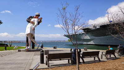
San Diego is not the quiet peaceful town anymore.  It was by accident that we found Old Town Historic Park, most of which is now restored to its 1872 era.  From there we sifted carefully thru the rows and rows of traffic and found the Harbor and the Midway Aircraft Carrier Museum.  Luckily we got a great parking spot and were surprised to see the same Naval Sailor Kissing the Girl – Just like the one in Sarasota Florida!  San Diego is also famous for the Coronado Bridge and the Strand Boulevard.  After all that, H was done – and it was time to get out of town.  Did I mention the traffic?   We know the van does not make “U turns” as good as the bike does but she did her best and we did get out of town.   The beaches and the surfers are gone – we are heading east.


Friday, October 4, 2013

Las Vegas


 There may have been frost on the van at 7am but by noon it was 80 degrees and then up to the mid 90s by mid afternoon!

Our last section of Route 66 for a while was from Williams to Kingman and from there we headed north on Rt 93.  The next stop was in the very bottom corner of the state of Nevada - the 726 ft tall Hoover Dam and the magnificent view of Lake Mead behind it.   In 1994 we flew to Las Vegas with R&N and rented a car to drive out to see the famous huge dam.  If you are wondering – the dam is 45 ft thick at the top and 660 ft thick at the bottom! Now there is a skyscraper tall bridge that spans the Colorado River just 1500 ft down stream from the dam.  The river looks as if it is a mile below us but is really only 900 ft down.  ONLY?   The dam and bright blue lake that it holds back is just as breath taking as ever, however the lake level is way down and various islands are now clearly visible where there were none before.
 
From there it was 30 miles to Las Vegas.   Once we were settled in our motel, we bravely set out to walk the block to the “Strip”.  H’s first objective was to find one of the newer casinos – New York New York.  We recalled how busy the street was back in the day and today the street is 6 lanes wide with even more bumper-to-bumper traffic and sidewalks crowded with even more camera and cell phone toting tourists.  Thankfully there are now pedestrian escalators and walkways that cross over the streets, joining one brightly lit casino with the one next to it.   We started out at Bally’s, checked out Paris, crossed over to Excalibur, then to New York New York.  Down on street level we kept going, past Mirage with its red rock waterfalls and volcano and finally reached the Treasure Island Casino with the old pirate ship show.  The ships are still there and still put on a good show but it’s no longer all pirates but are now “vixens”.  As we journeyed the mile hike back to our motel after the sun had set, the millions of bright lights and flashing neon and LCD screens did their best to put our senses on overload!

In the morning we climbed in the van and attempted to go downtown but there were more casinos in front of us.  We parked in the Tropicana’s mostly empty lot and passed thru the spacious marble entryway.  Their breakfast buffet was $18 each so it was thru Tropicana and over several more bridges, finally ending up back at MGM.   In 1994 the downtown casino area was just being covered up with a high domed canopy and the streets were being turned into pedestrian walkways. Yes, the Golden Nugget’s flashing gold sign and the tall neon cowboy are still standing high up in the metal arches.  The cowboy’s hat is not as tall and his arm no longer waves to the passersby below.

Monday morning – we are both ready to blow this town and head for some peace and quiet.  We got it -  Rt 93 then further south on Rt 95.  The busy traffic of “Lost Wages” gave way to rolling low hills of the California high desert, passing thru small gray towns before ending back on Rt 40 and a portion of our Route 66!    Rt 62 led us west thru towns like 29 Palms and Yucca Valley before we entered into Joshua Tree National Forest.   From the highway the “forest” and mammoth rock formations were almost non-existent but once we were a few miles into the park the trees appeared everywhere and in the most twisted forms.  H even noticed that several of the cactus looking trees had bursts of pale yellow clusters of flowers growing out of the palm tree looking branches.  Double click on that picture and you should see the clusters just beginning to bloom!   Back on the highway we headed for Redland and Yucaipa California.


Sunday, September 29, 2013

California or Bust part 2


 Gotta keep moving!  Oklahoma, Texas, New Mexico and Arizona!   We’ve been putting between 350 and 450 miles on the van each day – jumping on and off of Interstate 44 ( and then 40 ) to catch the highlights of Historic Route 66.  Each day we’ve gone thru another time change that has thrown our body’s time systems off!   We’ve watched the terrain change from rolling farms to vast prairies of blowing waves of grasses, to miles and miles of scrubby brush with flat-topped dark colored hills in the distance.  Miles and miles of  - - miles and miles!  Cool at night and up to 90 degrees in the daytime!   Most of our accommodations have been just fine but we’ve also stayed in a typical “Route 66” vintage motel with no wifi and not much of any other accommodations – including a comfortable bed.


In Claremore, Ok, we stopped to see the Davis Gun Museum with its collection of OVER 10,000 guns.  Even H had trouble taking them all in! We saw a big silly looking blue whale sitting in a small pond just outside of Catoosa.  We drove thru towns with names like Sapulpa, Depew, Stroud and Chandler.  In Chandler we spotted a restored 1889 round red barn.   In Elk City we had our own early morning tour of their restored “Old Town” complete with the biggest Route 66 sign of all.  Texas had its share of small towns with their own collections of 66 memorabilia.  In Groom it was a leaning water tower and in Amarillo it is the line up of half buried Cadillacs, standing nose deep in the dirt by the highway.  In Santa Rosa, NM, we stopped to see the Blue Hole and adjoining park.  What a treat!  Too bad we left our snorkel stuff at home!  The water was deep rich blue and the temp was 61 degrees. The boulder-lined pool was 60ft across and 81ft deep and bubbled with 3000 ( Yes - 3 zeros! ) gallons of water per minute!


  We drove the entire Central Ave in Albuquerque, NM – the longest main street in the USA according to our “Route 66 Adventure Handbook”!  Arizona made us stop and once again drive thru the beautiful and ever amazing Painted Desert and Petrified Forest National Park!  The last time we were here we were on the bike and did not get to stop at too many turnouts.  This time, H gave in and was amazed by the colorful vistas and the mammoth deep veined logs that have been turned to stone and crystal over the millions of years!  Holbrook Arizona has a Wigwam Village Motel that drew us in to check out the restored tourist cabins, each in the shape of a large white teepee.  Each had a sweet old classic car parked by its door.   Several old tow trucks were parked under the front canopy as if ready to go assist a tourist having car trouble on a hot day.  


And then there was Winslow!   Remember the Eagles’ song – “Take It Easy”?  The lyrics call for standing on the corner in Winslow Arizona and also a line about a girl in a flat bed Ford, slowing down to take a look at me.  You bet – we were there!


Our goal for that day was to make Flagstaff – a pretty college town nestled at 7000 ft up in the mountains and surrounded by dark green Ponderosa Pines.  But I must mention that it is the home of Northern Arizona University and it was “Parents Week” so we pushed on - 27 miles more to Williams where motel rooms were more plentiful and lots more affordable!  Alas – they were also without the above-mentioned amenities.   H said we did have wifi but the room was too small to get the laptop in it!   The antique air-conditioner/heater did work well enough though since it was almost 90 degrees when we parked and there was frost on the van when we left the next morning!

Next is Nevada – Hoover Dam and Las Vegas, aka Lost Wages.

Wednesday, September 25, 2013

California or Bust

 Remember the old phrase “ California or Bust’?  H and I are resurrecting it and have begun our crusade to follow Rt 66 to the Pacific Coast.  We have been to the beginning of the “Mother Road” in downtown Chicago and a few years ago we followed the “Lincoln Highway”, Rt 33 to Joliet Illinois and then followed Rt 66 to St Louis.   Yep - see previous blogs for that trip.

Monday morning, September 23rd, we pulled out of our driveway – in our 2006 Chrysler Minivan – with NO trailer and no worries - we had 4 new tires and a fresh oil change!     The day’s goal was to reach St Louis and we came within 45 miles of our goal.  425 miles in one day was way more than what we’ve been used to on our trips to and from Florida – or anywhere!  We fell asleep way too soon and consequently woke up WAY to early so we hit the highway before sun up.  We were just in time to get in line with all the “go to work”- stop and go traffic, trying to squeeze into downtown St Louis from all the various tentacles of roadways that merged on the bridge over the Mississippi River.


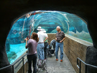
The St Louis Zoo opened at 9am and we were there, ready to explore and enjoy.  The zoo and the neighboring beautiful Forest Hill Park were part of the 1904 Louisiana Purchase Exposition, informally known as the St Louis World’s Fair. The park and zoo covered 1300 acres!  Like our beloved Toledo Zoo, this zoo still embraces the wonderful architecture of the beautiful old buildings and has also designed some fabulous new enrichment enclosures for it’s collection of interesting animals.  Even though they have Asian elephants, they have no African elephants.  NO polar bears (since 2009), but there is an amazing Sea Lion underwater viewing tunnel!  H fell in love with a young seal with big dark sad eyes! The hippo area was amazing and everyone laughed at the display about hippo poop!  Gorillas, chimps and some up close, in your face red orangutans completed our big ape tour.  I could go on and on about all the animals and birds, the train, the flowers and the myriad of fabulous fountains and ponds but the rest of Forest Park and the history of the Worlds Fair that was held there is mind-boggling!  Even though most of the buildings were destroyed, some remain and are now other museums and venues.  Time to head back to the highway and on  west.

Rt 44 has replaced Rt 66 in most motorists need for speed to get from one town to the next but in a lot of areas the multi laned highway is right next to the old 2 lane road that is fondly called “The Mother Road”.  We veered off of the expressway to slow down and experience travel as it used to be.  Once the 2 lane ended in a dirt road but mostly it led thru small towns with kookie old buildings and funky “tourist” gift shops.  We stopped at the Route 66 State Park, which has a museum housed in an old inn that was once a popular stopping place by the side of the original old road.  One of the displays includes a 1988 Yamaha Route 66 motorcycle.  The one in our garage is in better condition than theirs!   We learned that bike was only produced for 2 years and only in 2 colors – black and the pretty tan of H’s bike! 

Rt 44(and 66) crossed the state and went from the hills of St Louis to the rugged terrain on south central Missouri and then the plateau between Springfield and Joplin.  From golden fields of corn and beans being combined in clouds of red dust by mammoth machines to the thick green forests on the edge of the Ozarks.    We’ve made it to Exit 8 in Joplin and are “camped” for the night in a newly renovated Days Inn.  Tomorrow we tackle Oklahoma!   Come with us!


Wednesday, August 28, 2013

Up North Moving on


 On moving day we ALWAYS have breakfast on the way!   I mean, when you have to go from one side of the state to the other – Up North, it’s a long, long trip – maybe 40 miles.  And then another 30 or so down to East Jordan, which is south of Charlevoix!  Remember – left hand, left side of ring finger?  It was a good ride - past farms and thru deep green forests with no hectic I75 traffic.   On the north side of Petoskey we found a nice family type restaurant that had a parking lot big enough for the truck/trailer and Bud’s motor home with our boat attached behind it.  The added bonus was that the food was good!    On down to Boyne City where we once again found a parking lot big enough for both of us, so we walked the town and explored the two local hardware stores.  Bud led us out of town and his GPS took us along the coast of beautiful Lake Charlevoix and down to the East Jordan Tourist Park.  Instead of SPFB (Florida)  - - - this trip it is SPMB (Michigan)!   Just like Waterways - we’ve been here before!  The facilities are the same and the sewer hookups are still goofy but the scenery is outstanding and the town is still quaint.    The foundry across the bay still has the large American flag painted on it’s huge wall and the night sounds of the men working, still lull us to sleep.

We pushed our luck and guessed at picking the “best” day - weather wise, to put the boat in the water for our 14-mile run up the lake to Charlevoix and the long narrow channel out to Lake Michigan.   We out ran the clumps of heavy gray clouds and by the time we moored at the city docks – the sun was popping thru and shining down on the pretty little tourist town. Before we even finished securing the boat we were met by a group of inquisitive ducks that were cruising the harbor looking for handouts.   C and I tried our best to find another great deal but thankfully for our wallets – nothing caught our eye. 

Out thru the narrow, steel break wall guarded channel, we found the fairly calm sea of clear blue, unsalted and shark free, waters of Lake Michigan!    We cruised up the coast towards the giant dunes farther north  before cutting a large swath in the waves to circle back to the channel.  C and I reclaimed our perches on the back of the boat so we could have a better view of all the magnificent homes that line the harbor.  On each visit to their watery backyards, we still find something new that amazes us.